My Connect the Dots Tour - Day 1, Columbia, Mo. to Hermann, MO. August 2014
After all the planning and preparation, it was finally time to hit the road.
 |
| Ready to Roll - DALMAC Jersey |
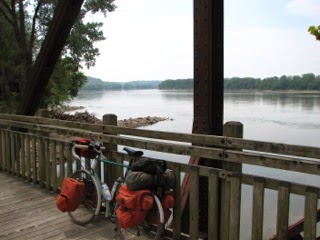
My bike was in my mother-in-law’s garage, loaded with my final selection of clothing and gear. The three of us shared a breakfast, and I made sure all my non-touring luggage was packed for Linda, who would be driving home at the end of the week. I said my goodbye’s to Mrs. Brown, who was still worried I was taking on too much of a challenge. Then after a few pictures, Linda and I got on our bikes and rode out of the driveway, starting on a very warm, sunny morning.
It was a short 3 miles to the MKT Spur trail head in downtown Columbia. We were able to take bike paths and bike lanes all the way there, as Columbia is working very hard to be a Bike Friendly city. The first mile of the trail was paved, and then it became crushed limestone. Linda rode a few more miles with me, and then we paused, said our goodbye’s and I was on my own.
The spur leaving Columbia actually heads south
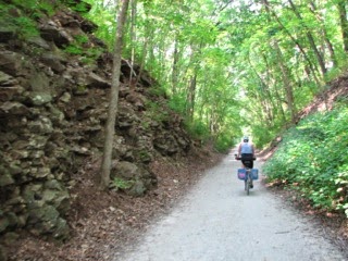 |
| Linda escorts me thru a cut on the Columbia Spur |
and west, crossing a number of small creeks, and passing through some minor rock cuttings, each just a few dozen feet above the trail. Many of the crossings were on old iron rail road bridges, and in a few places tubes take the trail under the busier roads. The grade is very mild, with just a few levee crossings as you pass through farm fields.
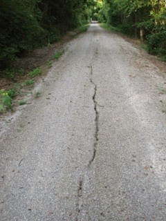
Occasionally I had to watch for long horizontal cracks in the limestone trail, where is it sliding off the original raised railbed, and there were a few soft spots where a thin layer of fine crushed limestone was loose. But for the most part it was smooth riding at a steady 11-13 miles per hour.
 |
| Trail Hazard |
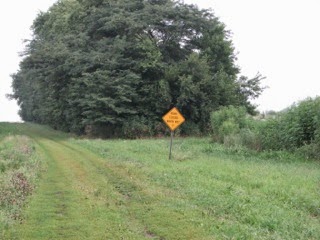
I finally hit the trail head at McBaine, and I had my first surprise; the first warning sign that the trail was closed. At the same time, I realized Linda had been trying to call me. I checked in with her, and she had met a pair of riders from Europe, headed back into Columbia, who had found the same barrier while riding west to east, and decided ride back toward Columbia to find a way to around the closure.
This reaffirmed one thing I had known in advance about the Katy; current information is very difficult to find. Oddly enough, Missouri State Parks does not consider it necessary to post detours for significant closures. The lack of detour information is unfortunate for the couple from Europe, who did not realize the cross road at the closure was Route K, the first leg of a faded, hand-written detour description a “local” had posted on the barrier.
Another challenge to navigating the Katy is the private “Katy Trail” website (
www.bikekatytrail.com) is at least 5 years out of date; yet if you Google “Katy Trail”, it is one of the first sites listed. Even the Missouri Parks
information site is at least a year or two out of date with regards facilities on or near the trail. (Too it’s credit, BikeKatyTrail.com does have a handy interactive map feature for determing distances between points along the trail.)
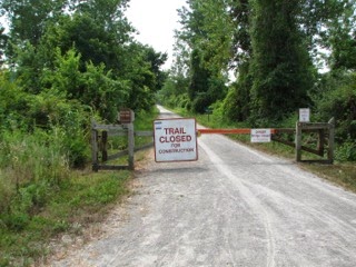 |
| Why is no detour posted? |
Don’t get me wrong, the Katy Trail is a great riding experience for day trippers driving to trailheads from cities and major towns like Columbia, Booneville or Jefferson City. But if you are trying to use the Katy Trail for point-to-point travel, the reality is you might as well be on the Appalachian Trail. The small river and railroad towns along the way have all faded with time, offering few open businesses, and those will have erratic open days and hours. Many of the official trail heads do not even offer a source of water. My decision to start the day with over a gallon water and GatorAde on board had been a good call.
When I hit that closure, it was pretty obvious I had at least an hour of detour time to move 4-5 miles up the trail. And the handwritten note also mentioned that much of the detour was poor condition gravel road. If that was the case, I might as well skip the Katy and head overland to my alternate North route. So I flipped a mental coin, and about 20 minutes later, I was east of the trail closure. During that 4 miles, I didn’t see a workman, no bridge was out, and there was no interruption in the trail. The word pointless came to mind as I moved along.
 |
| First sight of the river, near Cooper's Landing |
Compared to pavement, riding on crushed limestone is noisy, and it slows your pace. As the morning went on, I was averaging between 11 and 13 miles per hour. Doing some math in my head, it came to roughly 1,000 feet per minute, or 2 bike lengths a second. Every 4 to 5 minutes or so, I would count down another mile marker, and the surroundings would change almost at random.
You would be riding along a corn or bean field for a few minutes, and then a bluff would be on your left, and river would would come within feet of the trail. Or you could be in a tunnel of trees, with a hint of water to your right, and peeks at rock walls through a tangle of vines and branches. And then over the next few minutes, the river would push away from the trail, sometimes with a dry or soggy slough, or into another corn field reaching far to the south, where the bluffs and rolling hills on the south bank of the river were lost in haze.
 |
| The old bank in Tebbetts, Jesse James hid nearby. |
A town sign would come into view, sometimes followed by a line of buildings and an abandoned cement elevator, all along a street a paralleling the old rail bed. But sometimes all that came after the town sign would be a gravel road crossing the trail, the only indication you had been through the town was the back of an east facing town sign on the north side of the trail, passed a minute or two later, after another 1,000 feet or so. Easley, Cooper’s Landing, Wilton, Hartsburg, Claysville, all rolled past at 1,000 feet per minute.
Just before Wilton, I found another bridge closure, but this one had a short marked detour on a paved road. It came at the price of a steep 1/8th of mile climb over the bluff that guided a creek into Wilton. I was up and over that, then back on the trail after less than a mile on pavement. Passing through Wilton I met a couple on bikes, pulling a kid trailer with no kid, but filled with camping gear, also headed east. They had left Boonville early in the morning, and had also encountered the McBaine closure. They had taken the handwritten detour, the husband talking the wife out of riding around the barricades, so I may have started a family argument. We chuckled, wished each other luck, and I rode on.
As I continued east the trail was now miles north and west of the river, and the Missouri state capitol, Jefferson City slowly climbed out of a hazy cornfield. The trail crosses under highway 63 a few miles north of Jefferson City (Jeff City to anyone from Missouri), and again, there was no sign of any open business within miles of the trail head. Fortunately, there was a working restroom with running water, and I was able to top off my Camelbak.
Wainwright and Tebbetts were the next two near ghost towns, In Tebbetts, the one stone building on the main street was an old bank building that looked old enough to be from the Civil War. Robbed by Jesse James, I thought to myself in jest. And there at the historic summary under the trailhead canopy was a bit of trivia about the the polite young stranger who wintered in Tebbetts after the Civil War, sang in the church choir, and was rumored to have been Mr. Howard.
It was finally at Mokane, after 57 miles, that I found the first open store within site of the trail. Outside were a half dozen dusty bikes, and inside were the half dozen, dusty, 20-something guys riding them, all working their way though snacks and Gatorade. I bought myself two quarts of Gatorade, and then split a bag of ice with them after filling my CamelBak. They shared a gallon of water they had purchased.
 |
| Bluff near Rhineland, MO |
I learned they had first ridden the Katy together as college freshmen, and this was their 4th annual gathering. They were on a mix of road and mountain bikes, and carrying clothing, but not camping. They were headed toward McKittrick and a bed and breakfast overnight, but were running late due to a number of flat tires earlier in the day. We left Mokane together and chatted for a few miles, but we soon separated, as they fell into very different paces and would stop to regroup.
Steedman was the next town up, with no store but an active tavern. It was late in the afternoon, and I kept heading east, grazing through the remainder of the grapes, apples and Clif bars I had started out with. That, along with 3 quarts of Gatorade, would be my meal for the day. I was already falling into my old bachelor habit of lunch-less touring.
Portland came up next, and this was a bit of history for Linda and I. In 1980, on a short 3-day tour out of Columbia, Linda and I had "jungle camped" here on the river bank, years before there was a Katy. Portland is now is now trail access point, and the trees we had tented between had survived the floods of 1993, but it was otherwise unchanged. I rolled on for another hour through Bluffton, and Rhineland, and finally passed under Route 19, the road to Hermann, and went on a quarter mile to McKittrick, the next town on the trail.
 |
| Sun setting from the Hermann bridge. |
McKittrick had no open store, and there was no campground (again) despite the camping icon. I had about 45 minutes of daylight left, so I rolled back to Route 19, and rode the 3 miles into Hermann, crossing the Missouri River in the process. After a stop on the bridge for a sunset picture, Dan Henry’s guided me directly to the city park and campground, and after 88 miles for my first day, I began to setup camp.
I was a bike tourist again.